
Wetlands Protection Act: Plain Language
https://malegislature.gov/Laws/GeneralLaws/PartI/TitleXIX/Chapter131/Section40
This document is a plain-language translation of the Massachusetts Wetlands Protection Act (WPA). It was written to assist those seeking to better understand the Massachusetts WPA. This document presents the actual text of the Act side by side with a plain language presentation.
Italics are used where a reasonable assumption is made, but clarification may be needed.
Helpful links may be included in certain words or phrases in the plain language sections.
Please note that this effort is a voluntary citizen activity, and the author doesn’t claim to be a legal expert. You should always consult a legal expert if you need advice on these matters, if you are able to. Lacking that, you should real the actual text yourself and at least discuss it with others. At some point, a forum of some type may be installed for that purpose on this web site.
TOOLTIPS: Some words are underlined, indicating that you may hover over the word for a tooltip containing a definition. If there is a link in the tooltip, you may click on the defined term to access the link.
Actual Text
Plain Language
No person shall remove, fill, dredge or alter any bank, riverfront area, fresh water wetland, coastal wetland, beach, dune, flat, marsh, meadow or swamp bordering on the ocean or on any estuary, creek, river, stream, pond, or lake, or any land under said waters or any land subject to tidal action, coastal storm flowage, or flooding, other than in the course of maintaining, repairing or replacing, but not substantially changing or enlarging, an existing and lawfully located structure or facility used in the service of the public and used to provide electric, gas, sewer, water, telephone, telegraph and other telecommunication services, without filing written notice of his intention to so remove, fill, dredge or alter, including such plans as may be necessary to describe such proposed activity and its effect on the environment and without receiving and complying with an order of conditions and provided all appeal periods have elapsed.
The following types of wetlands are defined as protected under law (make each of these a link or a tool-tip):
- Banks
- Riverfront areas
- Fresh water wetlands
- Coastal wetlands
- Beaches
- Dunes
- Flats
- Marshes
- Meadows or swamps bordering the ocean
- Meadows or swamps bordering an estuary
- Meadows or swamps bordering a creek
- Meadows or swamps bordering a river
- Meadows or swamps bordering a stream
- Meadows or swamps bordering a pond
- Meadows or swamps bordering a lake
- Land underneath any of the above defined bodies of water
- Land subject to tidal action
- Land subject to coastal storm flow or flooding
It is unlawful to perform the following actions in these areas:
- Removal
- Filling
- Dredging
- Altering
However, if there is an existing lawfully located public service structure/facility in any of these places, work may be done to maintain, repair or replace them, as long as the structure is not substantially changed or enlarged. Such structures may provide:
- Electric
- Gas
- Sewer
- Water
- Telephone/telegraph/telecommunication
Outside of the scope of maintaining existing public services, if a person wishes to perform any restricted action in any protected area, they need to file a written notice of intent (NOI). The applicant should provide detailed plans, including a description of the proposed activity and how it will affect the environment. The applicant will be expected to comply with an order of conditions (OOC) and wait until all relevant appeals periods have passed.
Said notice shall be filed by delivery in hand to the conservation commission or its authorized representative or by certified mail, return receipt requested, to said commission, or, if none, to the board of selectmen in a town or the mayor of a city in which the proposed activity is to be located.
The NOI can be delivered in two ways:
- By hand
- By certified mail, return receipt requested
The NOI must be delivered to the conservation commission – or the commission’s authorized representative – of the town in which the work is to be performed.
If there is no conservation commission, then the NOI must be delivered to the board of selectmen of the town, or alternatively to the mayor.
Upon such filing, the receipt of such notice shall be acknowledged in writing on the face thereof and shall include the time and date so received.
A person delivering said notice by hand shall be given a receipt in writing acknowledging the time and date of such filing.
If the applicant delivers the NOI by hand, in-person, the applicant must be given a receipt that indicates the date and time of receipt.
Copies of such notice shall be sent at the same time by certified mail to the department of environmental protection.
To defray state and local administrative costs each person filing such a notice shall pay a filing fee, determined on a sliding scale basis by the commissioner of administration after consultation with the secretary of environmental affairs. Fifty percent of any filing fee in excess of twenty-five dollars shall be made payable to the department of environmental protection, in a manner to be determined by the commissioner of environmental protection, at the same time as the copies of the notice are sent to the department of environmental protection. The remainder of said fee shall be made payable to the city or town; provided, that said remainder shall be expended solely by the local conservation commission for the performance of its duties under this chapter and shall accompany the copy of the notice sent to the city or town.
To file an NOI, the applicant must pay a filing fee.
The fee is determined by the commissioner of administration in consultation with the secretary of environmental affairs. A sliding scale is set for this fee. (Question: Under what circumstances is this scale adjusted?)
If the fee is more than $25, half of the amount in excess of $25 must be paid to the DEP. The DEP will decide how this amount must be paid. This portion of the fee must accompany the copy of the NOI that goes to the DEP.
The rest of the fee must be paid to the town in which the work is proposed. This amount must be spent only by the local conservation commission in order to carry out its duties. This portion of the fee must accompany the copy of the NOI that goes to the town.
Example: You want to perform an action in the town of Bernardston on or near a wetland. The NOI filing fee is $250 (for the purpose of this example). Subtract $25 from $250, which is $225. Half of that – $112.50 – must accompany the copy of the NOI that goes to the DEP. The remainder – $137.50 ($250 minus $112.50) – goes to the town of Bernardston along with the copy of the NOI going to Bernardston.
No such notice shall be sent before all permits, variances, and approvals required by local by-law with respect to the proposed activity, which are obtainable at the time of such notice, have been obtained, except that such notice may be sent, at the option of the applicant, after the filing of an application or applications for said permits, variances, and approvals; provided, that such notice shall include any information submitted in connection with such permits, variances, and approvals which is necessary to describe the effect of the proposed activity on the environment.
Before submitting an NOI, the applicant has to obtain all relevant permits, variances and approvals required by local law. However, the applicant may also file the NOI after filing for all relevant permits, variances and approvals as long as the NOI documents these filings. Documenting the filing of permits, variances and approvals in the NOI helps to describe the effect of the proposed activity on the natural environment.
Upon receipt of any notice hereunder the department of environmental protection, hereinafter called the department, shall designate a file number for such notice and shall send a notification of such number to the person giving notice to the conservation commission, selectmen or mayor to whom the notice was given. Said notification shall state the name of the owner of the land upon which the proposed work is to be done and the location of said land.
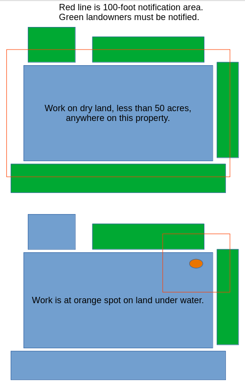
Any person filing a notice of intention with a conservation commission shall at the same time give written notification thereof, by delivery in hand or certified mail, return receipt requested, to all abutters within one-hundred feet of the property line of the land where the activity is proposed, at the mailing addresses shown on the most recent applicable tax list of the assessors, including, but not limited to, owners of land directly opposite said proposed activity on any public or private street or way, and in another municipality or across a body of water. When a notice of intent proposes activities on land under water bodies and waterways or on a tract of land greater than 50 acres, written notification shall be given to all abutters within 100 feet of the proposed project site. For the purposes of this section, ”project site” shall mean lands where the following activities are proposed to take place: dredging, excavating, filling, grading, the erection, reconstruction or expansion of a building or structure, the driving of pilings, the construction or improvement of roads or other ways and the installation of drainage, sewerage and water systems, and ”land under water bodies and waterways” shall mean the bottom of, or land under, the surface of the ocean or an estuary, creek, river stream, pond or lake. When a notice of intent proposes activity on a linear shaped project site longer than 1,000 feet in length, notification shall be given to all abutters within 1,000 feet of the proposed project site. If the linear project site takes place wholly within an easement through another person’s land, notice shall also be given to the landowner. Said notification shall be at the applicant’s expense, and shall state where copies of the notice of intention may be examined and obtained and where information regarding the date, time and place of the public hearing may be obtained. Proof of such notification, with a copy of the notice mailed or delivered, shall be filed with the conservation commission.
When filing an NOI, the applicant also has to notify all landowners within 100 feet of the boundaries of the property where the work in the NOI is proposed. The applicant can either hand-deliver this notice or send it by certified mail, return receipt requested. The applicant can get the address of such landowners from the local assessor’s office. This notice must be given even if the landowner is across a street, in another town, or across a body of water. The 100-foot rule still applies.
When the work described in the NOI involves land under water, or covers a tract of land greater than 50 acres, written notice must be given to landowners within 100 feet of the project site.
Recap: Work on dry land covering less than 50 acres requires notifying landowners within 100 feet of the property boundaries. Work on land under water or covering more than 50 acres requires notifying landowners within 100 feet of the project site.
The project site is defined by any of the following activities taking place:
- Dredging
- Excavating
- Filling
- Grading
- The erection, reconstruction or expansion of a building or structure
- The driving of pilings
- The construction or improvement of roads or other ways
- The installation of drainage, sewerage and water systems
Land under water includes the bottom of, or land under the surface of any of the following:
- The ocean
- An estuary
- A creek
- A river
- A stream
- A pond
- A lake
When an NOI proposes work on a project site shaped like a line, and that line is longer than one thousand feet, all landowners within one thousand feet of the project site need to be notified.
If the linear (line-shaped) project site will be entirely on an easement through someone else’s property, the owner of this property must be notified.
Notification of nearby landowners must be paid for by the applicant. Notifications must provide information about where the NOI can be viewed, and must also state the day, time and place of the relevant public hearing.
Proof that notifications were mailed or delivered must be filed with the town’s conservation commission.
Within twenty-one days of the receipt by a conservation commission of a written request made by any person and sent by certified mail, said commission shall make a written determination as to whether this section is applicable to any land or work thereon. When such person is other than the owner, notice of any such determination shall also be sent to the owner.
Anyone can ask a conservation commission whether the WPA applies to a specific property or proposed work. This request should be made in writing.
The conservation commission then has 21 days to determine whether the WPA applies to a specified property or work to be done.
The 21-day rule begins when the commission receives this request for applicability.
If the person making the request is not the landowner, this notice from the commission must also be sent to the landowner.
The term ”bogs” as used in this section shall mean areas where standing or slowly running water is near or at the surface during a normal growing season and where a vegetational community has a significant portion of the ground or water surface covered with sphagnum moss (Sphagnum) and where the vegetational community is made up of a significant portion of one or more of, but not limited to nor necessarily including all, of the following plants or groups of plants: aster (Aster nemoralis), azaleas (Rhododendron canadense and R. viscosum), black spruce (Picea mariana), bog cotton (Eriophorum), cranberry (Vaccinium macrocarpon), high-bush blueberry (Vaccinium corymbosum), larch (Larix laricina), laurels (Kalmia angustifolia and K. polifolia), leatherleaf (Chamaedaphne calyculata), orchids (Arethusa, Calopogon, Pogonia), pitcher plants (Sarracenia purpurea), sedges (Cyperaceae), sundews (Droseraccae), sweet gale (Myrica gale), white cedar (Chamaecyparis thyoides).
A bog is an area where all of these conditions are met:
- Standing or slowly running water is near or at the surface during normal growing seasons
- A significant portion of the ground or water is covered with sphagnum moss
- The vegetation is made up of a significant portion of any combination of the following:
The term ”coastal wetlands”, as used in this section, shall mean any bank, marsh, swamp, meadow, flat or other lowland subject to tidal action or coastal storm flowage.
“Coastal wetlands” include the following land features:
- Banks
- Marshes
- Swamps
- Meadows
- Flats
- Any lowland
What makes them “coastal wetlands” is when these features interact with tides, or are affected by storm flowage along the coast.
The term ”freshwater wetlands”, as used in this section, shall mean wet meadows, marshes, swamps, bogs, areas where groundwater, flowing or standing surface water or ice provide a significant part of the supporting substrate for a plant community for at least five months of the year; emergent and submergent plant communities in inland waters; that portion of any bank which touches any inland waters.
Freshwater wetlands may be any of the following:
- Wet meadows
- Marshes
- Swamps
- Bogs
- Areas where groundwater, flowing water or standing water/ice play a major role in plant lifecycles for at least five months per year
- areas containing plants that exist above and below the surface of inland water
- any part of a bank that borders inland water
Actual text:
The term ”swamps”, as used in this section, shall mean areas where ground water is at or near the surface of the ground for a significant part of the growing season or where runoff water from surface drainage frequently collects above the soil surface, and where a significant part of the vegetational community is made up of, but not limited to nor necessarily include all of the following plants or groups of plants: alders (Alnus), ashes (Fraxinus), azaleas (Rhododendron canadense and R. viscosum), black alder (Ilex verticillata), black spruce (Picea mariana), button bush (Cephalanthus occidentalis), American or white elm (Ulmus americana), white Hellebore (Veratrum viride), hemlock (Tsuga canadensis), highbush blueberry (Vaccinium corymbosum), larch (Larix laricina), cowslip (Caltha palustris), poison sumac (Toxicodendron vernix), red maple (Acer rubrum), skunk cabbage (Symplocarpus foetidus), sphagnum mosses (Sphagnum), spicebush (Lindera benzoin), black gum tupelo (Nyssa sylvatica), sweet pepper bush (Clethra alnifolia), white cedar (Chamaecyparis thyoides), willow (Salicaceae).
Plain language:
A swamp is an area where the following conditions are met:
- Groundwater is either:
- at or near the surface of the ground for a significant part of the growing season, or
- formed from runoff water collecting above the soil surface
- Plant life is made of up any combination of the following:
- alders
- ashes
- azaleas
- black alder
- black spruce
- button bush
- American or white elm
- white hellebore
- hemlock
- highbush blueberry
- larch
- cowslip
- poison sumac
- red maple
- skunk cabbage
- sphagnum moss
- spicebush
- black gum tupelo
- sweet pepper bush
- white cedar
- willow
Actual text:
The term ”wet meadows”, as used in this section where ground water is at the surface for a significant part of the growing season and near the surface throughout the year and where a significant part of the vegetational community is composed of various grasses, sedges and rushes; made up of, but not limited to nor necessarily including all, of the following plants or groups of plants: blue flag (Iris), vervain (Verbena), thoroughwort (Eupatorium), dock (Rumex), false loosestrife (Ludwigia), hydrophilic grasses (Gramincae), loosestrife (Lythrum), marsh fern (Dryopteris thelypteris), rushes (Juncaceae), sedges (Cyperaceae), sensitive fern (Onoclea sensibilis), smartweed (Polygonum).
Plain language:
A wet meadow is an area where the following conditions are met:
- Ground water is at the surface for a significant part of the growing season
- Ground water is near the surface throughout the year
- Plant life is generally composed any combination of the following:
- blue flag
- vervain
- thoroughwort
- dock
- false loosestrife
- hydrophilic grasses
- loosestrife
- marsh fern
- rushes
- sedges
- sensitive fern
- smartweed
Actual text:
The term ”marshes”, as used in this section, shall mean areas where a vegetational community exists in standing or running water during the growing season and where a significant part of the vegetational community is composed of, but not limited to nor necessarily including all, of the following plants or groups of plants: arums (Araceae), bladder worts (Utricularia), bur reeds (Sparganiaceae), button bush (Cephalanthus occidentalis), cattails (Typha), duck weeds (Lemnaceae), eelgrass (Vallisneria), frog bits (Hydrocharitaceae), horsetails (Equisetaceae), hydrophilic grasses (Gramineae), leatherleaf (Chamaedaphne calyculata), pickerel weeds (Pontederiaceae), pipeworts (Eriocaulon), pond weeds (Potamogeton), rushes (Juncaceae), sedges (Cyperaceae), smartweeds (Polygonum), sweet gale (Myrica gale) water milfoil (Halcragaceae), water lilies (Nymphaeaceae), water starworts (Callitrichaceae), water willow (Decodon verticillatus).
Plain language:
A marsh is an area where the following conditions are met:
- Vegetation exists in standing or running water during the growing season
- Plant life is made up of any combination of the following:
- arums
- bladder worts
- bur reeds
- button bush
- cattails
- duck weeds
- eelgrass
- frog bits
- horsetails
- hydrophilic grasses
- leatherleaf
- pickerel weeds
- pipeworts
- pond weeds
- rushes
- sedges
- smartweeds
- sweet gale
- water milfoil
- water starworts
- water willow
Actual text:
The term ”Densely developed areas”, as used in this section shall mean, any area of ten acres or more that is being utilized, or includes existing vacant structures or vacant lots formerly utilized as of January first, nineteen hundred and forty-four or sooner for, intensive industrial, commercial, institutional, or residential activities or combinations of such activities, including, but not limited to the following: manufacturing, fabricating, wholesaling, warehousing, or other commercial or industrial activities; retail trade and service activities; medical and educational institutions; residential dwelling structures at a density of three or more per two acres; and mixed or combined patterns of the above. Designation of a densely developed area is subject to the secretary of the executive office of environmental affair’s approval of a city or town’s request for such designation. Land which is zoned for intensive use but is not being utilized for such use as of January first, nineteen hundred and ninety-seven or which has been subdivided no later than May first, nineteen hundred and ninety-six shall not be considered a densely developed area for the purposes of this chapter.
Plain language:
The term “densely developed area” is defined by meeting the following criteria:
- Either of the following is true:
- Area is at least 10 acres in size
- Includes vacant structures that were used as of January 1, 1944 or earlier (The assumption is if this is true, then the area in which these structures is located may be smaller than 10 acres.)
- The area is/was used for any combination of the following:
- Intensive industrial purposes
- Intensive commercial purposes
- Intensive institutional purposes
- Intensive residential activities
- Specific activities may include, but aren’t limited to:
- Manufacturing
- Fabrication
- Wholesaling
- Warehousing
- Other commercial/industrial activities
- Retail trade and services
- Medical institutions
- Educational institutions
- Residential dwelling with at least 3 people per 2 acres
An area may be designated “densely developed” by the secretary of the executive office of environmental affairs, after a city or town requests this designation.
For the purposes of the Wetlands Protection Act, land is not considered densely developed if:
- The land is zoned for intensive use but has not been used in such a way since January 1, 1997, or
- The land has been subdivided no later than May 1, 1996.
Actual text:
The term ”Mean annual high-water line”, as used in this section, shall mean with respect to a river, the line that is apparent from visible markings or changes in the character of soils or vegetation due to the prolonged presence of water and which distinguishes between predominantly aquatic and predominantly terrestrial land. The mean high tide line shall serve as the mean annual high water line for tidal rivers.
Plain language:
This definition applies to rivers.
The prolonged presence of water may lead to:
- Visible markings
- Changes in soil characteristics
- Changes in vegetation
These visible markings or changes in soil or vegetation mark a line between land that is predominantly aquatic and land that is predominantly terrestrial.
For tidal rivers, the average of all observed high-water levels will be used as the mean annual high water line.
Actual text:
The term ”River”, as used in this section, shall mean a natural flowing body of water that empties to any ocean, lake, or other river and which flows throughout the year.
Plain language:
The actual text is fairly straightforward in this particular definition.
Actual text:
The term ”Riverfront area”, as used in this section, shall mean that area of land situated between a river’s mean annual high-water line and a parallel line located two hundred feet away, measured outward horizontally from the river’s mean annual high-water line. This definition shall not create a buffer zone, so-called, beyond such riverfront area. Riverfront areas within municipalities with (i) a population of ninety thousand or more persons or (ii) a population density greater than nine thousand persons per square mile, as determined by the nineteen hundred and ninety federal census; (iii) that are within densely developed areas as defined herein; (iv) land in Waltham between the Charles river on the north, and the Crescent street and Pine street on the south, and the intersection of the Charles river and a line extended from the center line of Walnut street on the west, and the railroad right-of-way now or formerly of the Boston and Maine Railroad on the east; or (v) property located in the town of Milton shown on Milton assessors Map G, Block 56, Lot 13, located on 2 Granite Avenue shall be defined as that area of land situated between a river’s mean annual high-water line and a parallel line located twenty-five feet away, measured outward horizontally, from the river’s mean annual high-water line. The riverfront area shall not include land now or formerly associated with historic mill complexes including, but not limited to, the mill complexes in the Cities of Holyoke, Taunton, Fitchburg, Haverhill, Methuen and Medford in existence prior to nineteen hundred and forty-six and situated landward of the waterside facade of a retaining wall, building, sluiceway, or other structure existing on the effective date of this act. The riverfront area shall not apply to any mosquito control work done under the provisions of clause (36) of section five of chapter forty, of chapter two hundred and fifty-two or of any special act or to forest harvesting conducted in accordance with a cutting plan approved by the department of environmental management, under the provisions of sections forty to forty-six, inclusive, of chapter one hundred and thirty-two; and shall not include any area beyond one hundred feet of river’s mean annual high water mark: in which maintenance of drainage and flooding systems of cranberry bogs occurs; in which agricultural land use or aquacultural use occur; to construction, expansion, repair, maintenance or other work on piers, docks, wharves, boat houses, coastal engineering structures, landings, and all other structures and activities subject to licensing or permitting under chapter ninety-one and its regulations; provided that such structures and activities shall remain subject to statutory and regulatory requirements under chapter ninety-one and section forty of chapter one hundred and thirty-one or is the site of any project authorized by special act prior to January first, nineteen hundred and seventy-three.
Plain language:
A riverfront area is the land between a river’s mean annual high-water line (defined above) and an imaginary line 200 feet directly away from the mean annual high-water line.
There is no buffer zone farther away from the river than this 200-foot boundary.
Under certain conditions, the riverfront area is bounded by a 25-foot boundary instead of a 200-foot boundary. These conditions are:
- If the riverfront area is within a town or city with at least 90,000 people
- If the riverfront area is within an area with a population density more than 9000 people per square mile, according to the 1990 federal census
- If the riverfront area is within a densely developed area as defined earlier in this Act
- If the riverfront area is in Waltham and is all of:
- Between the Charles River on the north and Crescent and Pine streets in the south, and
- The intersection of the Charles River and a line from the center of Walnut Street to the west, and
- Bounded on the east by the railroad right-of-way belonging now or in the past to Boston and Maine Railroad
- If the riverfront area is located in Milton, as shown on Milton assessors Map G, Block 56, Lot 13, located on 2 Granite Avenue
Riverfront areas shall not include land that is now or formerly associated with historic mill complexes. These mill complexes are defined as follows:
- The mill complex has existed since before 1946
- The mill complex is located landward of a retaining wall, building, sluiceway or other such structure
- These walls, buildings or sluiceways were in existence as of the effective date of this Act
Such complexes are found in, but not limited to:
- Holyoke
- Taunton
- Fitchburg
- Haverhill
- Methuen
- Medford
Riverfront areas do not apply to:
- Mosquito work done in accordance with Chapter 40, Section 5, Clause 36 (Title XIX is assumed)
- Work done in accordance with Chapter 252 (Mosquito work and Title XIX is assumed, given the flow of the actual text)
- Work done in accordance with “any special act” (This is vague and is possibly a loophole that should be filled)
- Forest harvesting conducted in accordance with a cutting plan approved by the department of environmental management, as long as such forest harvesting complies with Chapter 132, Sections 40-46 inclusive (Title XIX assumed)
Riverfront areas do not include land beyond 100 feet of the mean annual high-water mark when the following items occur:
- Drainage maintenance and flooding systems maintenance of cranberry bogs
- Agricultural or aquacultural land use
- Construction, expansion, repair, maintenance, or other work on:
- Piers
- Docks
- Wharves
- Boat houses
- Coastal engineering structures
- Landings
- Anything else subject to licensing/permitting under Chapter 91 (Title XIX assumed)
If the above items were not authorized prior to January 1, 1973, they are subject to Chapter 91 (Title XIX assumed), and Chapter 31, Section 40 (This Act – the Wetlands Protection Act).
Actual text:
The term ”Riverfront area boundary line”, as used in this section, shall mean the line located at the outside edge of the riverfront area.
Plain language:
This passage is fairly self-explanatory.
Actual text:
The conservation commission, selectmen or mayor receiving notice under this section shall hold a public hearing on the proposed activity within twenty-one days of the receipt of said notice. Notice of the time and place of said hearing shall be given by the hearing authority at the expense of the applicant, not less than five days prior to such hearing, by publication in a newspaper of general circulation in the city or town where the activity is proposed and by mailing a notice to the applicant and to the board of health and the planning board of said city or town. The conservation commission and its agents, officers and employees and the commissioner of environmental protection and his agents and employees, may enter upon privately owned land for the purpose of performing their duties under this section. No conditions shall be imposed, nor shall any determination be rendered by a conservation commission, in reference to this section, unless the conservation commission meets with a quorum present.
Plain language:
Once the town conservation commission (or selectmen or mayor) has received a notice regarding a proposed activity, they have 21 days to hold a public hearing about it.
The commission (or selectmen or mayor) need to publicly advertise the time and place of the hearing. The applicant must pay any publication fees related to such advertisement. The advertisement needs to be published at least 5 days before the hearing, in the town’s local newspaper. (While the actual text refers to a newspaper, not all small towns have one, so the assumption is to use whatever form of public notice the town generally uses for such things, such as posting flyers on a public notice board at town hall.)
Notice of the hearing must also, at the same time, be mailed to:
- The applicant
- The board of health of the town in question
- The planning board of the town in question
In order to carry out their duties related to this section (c. 131 s. 40) the conservation commission, its agents, officers and employees, are allowed to enter private land.
The conservation commission cannot make any official determinations unless the commission meets with a majority of the commissioners present.
Actual text:
If after said hearing the conservation commission, selectmen or mayor, as the case may be, determine that the area on which the proposed work is to be done is significant to public or private water supply, to the groundwater supply, to flood control, to storm damage prevention, to prevention of pollution, to protection of land containing shellfish, to the protection of wildlife habitat or to the protection of fisheries or to the protection of the riverfront area consistent with the following purposes: to protect the private or public water supply; to protect the ground water; to provide flood control; to prevent storm damage; to prevent pollution; to protect land containing shellfish; to protect wildlife habitat; and to protect the fisheries, such conservation commission, board of selectmen or mayor shall by written order within twenty-one days of such hearing impose such conditions as will contribute to the protection of the interests described herein, and all work shall be done in accordance therewith. If the conservation commission, selectmen or mayor, as the case may be, make a determination that the proposed activity does not require the imposition of such conditions, the applicant shall be notified of such determination within twenty-one days after said hearing. Such order or notification shall be signed by the mayor or a majority of the conservation commission or board of selectmen, as the case may be, and a copy thereof shall be sent forthwith to the applicant and to the department.
Plain language:
Make it a given that the relevant regulatory body may be any of: the town’s board of selectmen, a conservation commission, or the mayor.
After the hearing described above, the relevant regulatory body has 21 days to determine whether any combination of the following conditions apply to the area on which the proposed work is to be done:
- The area is significant to public or private water supply
- The area is significant to groundwater supply
- The area is significant to flood control
- The area is significant to storm damage prevention
- The area is significant to the prevention of pollution
- The area is significant to the protection of land containing shellfish
- The area is significant to the protection of wildlife habitat
- The area is significant to the protection of fisheries
- The area is significant to the protection of one or more riverfront areas
If any combination of these conditions are met, the regulatory body must impose restrictions designed to protect those conditions. The applicant must perform all work in accordance with those restrictions. The applicant must be given written notice of these restrictions within 21 days of the hearing.
If none of these conditions are met, the applicant must be notified by the regulatory body within 21 days of the hearing.
In either case, the notice must be signed by the regulatory body. If the body is multiple persons, it must be signed by the majority of those persons.
In addition to going to the applicant, a copy must be sent to the department. (The state Department of Environmental Protection is assumed.)
Actual text:
If a conservation commission has failed to hold a hearing within the twenty-one day period as required, or if a commission, after holding such a hearing has failed within twenty-one days therefrom to issue an order, or if a commission, upon a written request by any person to determine whether this section is applicable to any work, fails within twenty-one days to make said determination, or where an order does issue from said commission, the applicant, any person aggrieved by said commission’s order or failure to act, or any owner of land abutting the land upon which the proposed work is to be done, or any ten residents of the city or town in which said land is located, may, by certified mail and within ten days from said commission’s order or failure to act, request the department of environmental protection to determine whether the area on which the proposed work is to be done is significant to public or private water supply, to the groundwater supply, to flood control, to storm damage prevention, to prevention of pollution, to protection of land containing shellfish, to the protection of wildlife habitat or to the protection of fisheries or to the protection of the riverfront area consistent with the following purposes: to protect the private or public water supply; to protect the ground water; to provide flood control; to prevent storm damage; to prevent pollution; to protect land containing shellfish; to protect wildlife habitat; and to protect the fisheries. The commissioner of environmental protection or his designee also may request such a determination within said ten days. The party making any such request shall at the same time send a copy thereof by certified mail to the conservation commission, board of selectmen or mayor which conducted the hearing hereunder. If such party is other than the applicant, a copy of such request shall also be sent at the same time by certified mail to the applicant. Upon receipt of such request the department shall make the determination requested and shall by written order issued within seventy days of receipt of such request and signed by the commissioner or his designee, impose such conditions as will contribute to the protection of the interests described herein; provided, however, that said department shall notify the applicant within thirty days of the receipt of such request if his application or request is not in proper form or is lacking information or documentation necessary to make the determination. Such order shall supersede the prior order of the conservation commission, board of selectmen or mayor, and all work shall be done in accordance therewith, but in no event shall any work commence until ten days have elapsed following the issuance of said order. In the case of riverfront areas, no order issued by a conservation commission, board of selectmen, mayor, or the department shall permit any work unless the applicant, in addition to meeting the otherwise applicable requirements of this section, has proved by a preponderance of the evidence that (1) such work, including proposed mitigation measures, will have no significant adverse impact on the riverfront area for the following purposes: to protect the private or public water supply; to protect the ground water; to provide flood control; to prevent storm damage; to prevent pollution; to protect land containing shellfish; to protect wildlife habitat; and to protect the fisheries, and (2) there is no practicable and substantially equivalent economic alternative to the proposed project with less adverse effects on such purposes. An alternative is practicable and substantially economically equivalent if it is available and capable of being done after taking into consideration: costs, and whether such costs are reasonable or prohibitive to the owner; existing technology; the proposed use; and logistics in light of overall project purposes. For activities associated with access for one dwelling unit, the area under consideration for practicable alternatives will be limited to the lot; provided, that said lot shall be on file with the registry of deeds as of the August first, nineteen hundred and ninety-six. For other activities including, but not limited to, the creation of a real estate subdivision, the area under consideration shall be the subdivided lots, any parcel out of which the lots were created, and any other parcels that are adjacent to such parcel or adjacent through other parcels formerly or presently owned by the same owner at any time on or after August first, nineteen hundred and ninety-six or any land which can reasonably be obtained; provided, that an ownership interest can reasonably be obtained after taking into consideration: cost, and whether such cost is reasonable or prohibitive to the owner; existing technology; the proposed use; and logistics in light of overall project purposes. At any time prior to a final order of determination by the department, any party requesting a determination may in writing withdraw the request, and such withdrawal shall be effective upon receipt by the department. Notwithstanding the withdrawal, the commissioner or his designee may continue the determination if he notifies all parties within ten days of receipt of the withdrawal. A copy of such order shall be sent to the applicant, to the conservation commission, board of selectmen or mayor which conducted the hearing hereunder. As used in this section the words ”wildlife habitat” shall mean those areas subject to this section which, due to their plant community composition and structure, hydrologic regime or other characteristics, provide important food, shelter, migratory or overwintering areas, or breeding areas for wildlife.
Plain language:
The following parties may ask that the Department of Environmental Protection (state department is assumed) step in and decide what restrictions this law imposes on a project (for environmental reasons already described):
- The applicant for the proposed work
- Anyone who feels unjustly treated by an issued order of conditions for proposed work
- Any 10 residents of the city or town where the proposed work is located
These parties may do so under the following conditions:
- The town conservation commission has failed to hold a hearing within 21 days of receiving a proposed project.
- The town conservation commission has failed to issue an order of conditions (or a notice of no restrictions) within 21 days of the required hearing.
- The town conservation commission has generally failed to respond within 21 days to anyone asking if proposed work has any restrictions as described in this section of law.
- An order of conditions has been appropriately issued, but the person inquiring feels unjustly treated by it.
They have 10 days after any of these conditions to contact the Department of Environmental Protection by certified mail.
The Commissioner of Environmental Protection or his designee may may also make this request within 10 days.
When making this request, the person doing so must use certified mail to send a copy of this request to the town conservation commission.
If the person making this request is not the applicant, this person must use certified mail to send a copy of the request to the applicant.
When the Department of Environment Protection receives this type of request, it must make the type of determination requested. The department has 70 days to impose any restrictions necessary to protect the types of environmental interests described earlier. These restrictions must be in writing and signed by the commissioner or their designee.
The Department of Environmental Protection has 30 days to notify the applicant if their application/proposal/request was not done correctly or lacks sufficient information to make a determination.
The decisions of the Department of Environmental Protection supersede that of local conservation commissions, boards of selectmen or mayors.
No work is permitted on a proposal until 10 days after the Department of Environmental Protection has issued its decision.
No matter what any regulatory body decides, no work is allowed on riverfront areas unless the applicant has provided convincing evidence that the proposed work – including mitigation measures – will not adversely impact protected environmental concerns as described earlier. The applicant must also provide convincing evidence that there isn’t a practical and economically equivalent alternative that does less damage.
Continue with translation: For activities associated with access for one dwelling unit, the area under consideration for practicable alternatives will be limited to the lot;